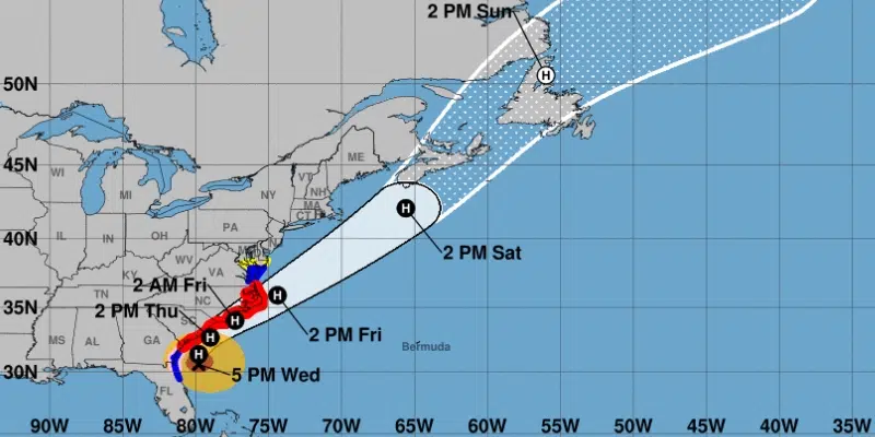
Hurricane Dorian is predicted to reach the Gulf of St. Lawrence and possibly the west coast of the province by tomorrow.
At least thirty people in the Bahamas have been confirmed dead in the wake of the hurricane, including a 27-year-old teacher from Windsor, Ontario. But by the time it reaches Newfoundland the powerful storm should be reduced to high winds and rain.
PAL Airlines and Aerospace Meteorologist Brian Walsh says today is forecast to be a beautiful day with lots of sunshine but the weather will hit the island late tomorrow and early Sunday.
Rain will begin Saturday afternoon with thunderstorms expected for the evening. Walsh says southeast winds will reach 80 km/h in eastern NL, 100 km/h in Central and 110 km/h on the West Coast. Wreckhouse area could get anywhere around 160 km/h winds.
Sun will break again on the eastern and central portion of the island on Sunday for a little while but rain will continue in the west.
Eastern Labrador could see 30-50 plus mm of rain. Walsh says models are showing that parts of Labrador with higher terrain could even see wet snow on Sunday.
West Coast and Northern Peninsula should expect 20-40 mm of rain on Sunday with winds of 130 km/h. With the high winds also comes high tides. Walsh says the southeast coast may see storm surge potential waves.
Winds will stay around 100km/h for the rest of the island until the storm fades early morning Monday.


