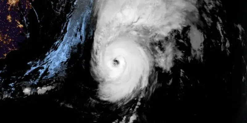
Residents of the province’s west and southwest coasts are being urged to prepare for strong winds, heavy rain and high storm surge as Fiona continues her march toward Atlantic Canada.
Canadian Hurricane Centre meteorologist Bob Robichaud says the storm, which is expected to merge with a low pressure system currently over the northeastern United States, is expected to make landfall tomorrow morning in eastern Nova Scotia.
However, what are being called strong and damaging winds will move into the region long before that.
Robichaud says the heaviest rain will be on the left side of the storm’s path, with upwards of 150 millimetres possible.
As a result, he says Newfoundland, which is on the right side of the storm, won’t see those extreme rainfall amounts, but about 100 millimetres is still possible.
The winds will be a concern, though, with gusts exceeding 100 km/h for most, and up to 170km/h in the notorious Wreckhouse area.
As the storm moves up the Gulf of St. Lawrence and into the Humber-Bay of Islands and Corner Brook areas, the fallout is not expected to be as extreme.
Robichaud says gusts of around 90 km/h are expected in that region, adding the rain won’t be as heavy, either. Nor is the storm surge in that area expected to be as much of an issue.
Prime Minister Justin Trudeau has also pledged support for whatever is needed from the federal government.
Hurricane Fiona is expected to make landfall in Atlantic Canada and Quebec this weekend. If you are in the region, please take proper precautions and listen to local authorities. Our team is in touch with the provinces – and we’re mobilizing resources to support however needed.
— Justin Trudeau (@JustinTrudeau) September 23, 2022
Earlier story
Fiona is now churning up the Atlantic at about 56 km/h and picking up speed.
The hurricane will take particular aim at the western part of Newfoundland, the south and southwest coasts. It is now down to Category 3, but is still a very powerful storm.
Fiona will make landfall in eastern Nova Scotia tomorrow morning so the winds pick up overnight as the storm expands in size. However, it is picking up speed, currently moving at 56 km/h.
The Port aux Basques area could get up to 100 mm of rain over the next two days with lesser amounts in the Corner Brook area and the south. However, storm surge and wave warnings are out for all south-facing coastlines and the coasts along the Gulf of St. Lawrence.
Rob Carroll, meteorologist with the Gander Weather Office, says records could be broken in the southwest corner.
There is the potential to have the highest water levels in the Port aux Basques area on record.
It should be a decent couple of days on the Avalon, the east coast and in central but those areas will feel some impact as will southern Labrador where winds tomorrow will get up to 70 km/h.
The Maritimes will begin to really feel the wrath tonight with a ton of water and high winds.
— ECCC Canadian Hurricane Centre (@ECCC_CHC) September 23, 2022
While Fiona has her sites set on the western portion of the island, the size of the storm means most of the province will feel its effects with high winds expected in most areas.
Residents across the province are being reminded to bring loose or vulnerable outdoor items indoors or secure them in place.
Residents are also reminded to have an emergency kit ready and to have their devices fully charged and to have batteries on hand for radios and other items.
Municipalities are also being asked to ensure roads, ditches and drains are clear of debris, that emergency plans are reviewed and ready and that provisions are made for the continuation of essential services.
It’s important to have an emergency kit to be prepared for three days – here’s how to prepare one on a budget: https://t.co/MGVsNVJbD9 pic.twitter.com/pZNYHFq3Kr
— Canadian Red Cross (@redcrosscanada) September 22, 2022
All crossings on the Gulf of St. Lawrence are cancelled for this evening, tomorrow and Sunday morning as Marine Atlantic prepares for Hurricane Fiona.
The storm is expected to bring sustained winds well in excess of 100 km/h, heavy storm surge and torrential rain to both Cape Breton and the southwest coast of the island.
Marine Atlantic says extra mooring equipment will be used to secure vessels at the dock both in Channel-Port aux Basques and North Sydney.
Meanwhile, Channel-Port-aux-Basques Mayor Brian Button says they’re preparing as best as they can.
Town crews are removing outdoor equipment, pots and other loose items and securing construction sites.
Button says residents of the region are used to preparing for powerful storms but admits, this one is especially concerning.
The City of Corner Brook is also bracing for the storm and hoping for the best.
Mayor Jim Parsons says tree trimming is keeping crews and contractors busy. “and we’re filling sandbags, a lot of sandbags” says Parsons.
Weather warnings and watches have been issued for Newfoundland and Labrador. Continue to monitor the forecast in your area and be prepared. For up-to-date forecast information visit: https://t.co/9NTZB2kA9W #GovNL #Fiona #nlwx pic.twitter.com/oUeAKWm8kn
— Justice and Public Safety NL (@JPS_GovNL) September 23, 2022


