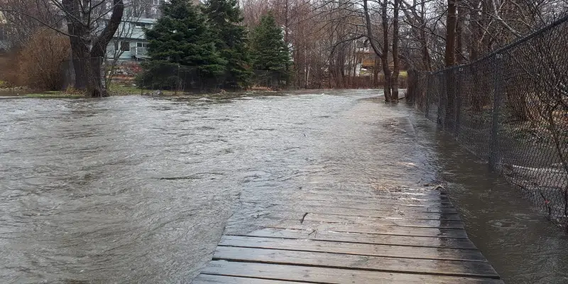
Flooding of popular trails in St. John’s over the weekend has one business owner questioning the delays in upgrades.
Chris Jerrett owns Freeride Mountain Sports, a cycle shop downtown. He posted a photo yesterday showing a part of the Rennies River trail submerged in water.
https://www.facebook.com/chris.jerrett.562/posts/504990623989527
Jerrett says delays in approving upgrades, including shared-use with bikes in some areas, is bad for the infrastructure and his business, but he says it’s the confusion and pushback from the public that really stings.
He says it’s still not clear what trails cyclists can or can’t use, or what the future holds for the master bike plan. Jerrett also says riders are disheartened by the backlash received over city efforts to incorporate bikes in shared-use trails.
Meanwhile, the city contacted VOCM to clarify that the ‘Kelly’s Brook Shared Use Path’ and the ‘Rennies River Flood Mitigation Project’ are two separate projects and that the construction of the shared-use trail adjacent to the river course would not address flooding concerns. The city says there is no intention to raise the trail elevation above the floodwater elevation and it would not solve the flooding issues in the area.
As per the city:
Council recently approved detailed design and construction for ‘Kelly’s Brook Shared Use Path’ project.
Update on river section of Trail (Jan 28, 2021)
Since announcing plans for the Kelly’s Brook Shared-Use Path, staff and council have been listening closely to public feedback and the project team has collected important data in the area of the trail to the rear of Winter Avenue. This area overlaps with the planned Rennies River flood mitigation berm. Based on the impacts a combined berm and widened trail would have in this segment, Council has revised the plan for this project and will no longer pursue a path alignment that follows the river’s edge between King’s Bridge Road and Portugal Cove Road. Given that the path behind St. Pat’s Ball Park along Kelly’s Brook between Rennies Mill Road and Carpasian Road is also not feasible, staff concluded that the Kelly’s Brook Shared-Use Path will need to follow a roadside alignment east of Carpasian Road. This new routing comes with significant obstacles, such as utility poles, on-street parking or travel lane reductions, and intersection alignments. Because of these obstacles, engaging with property owners and residents along these segments of Empire Avenue is critical to moving this plan forward.
https://www.engagestjohns.ca/kelly-s-brook-trail-catalyst-project-1-bike-master-plan
https://www.engagestjohns.ca/rennie-s-river-flood-mitigation