Hurricane Ernesto continues to barrel northward toward the Atlantic region.
The category 2 storm made landfall early this morning on the tiny British Atlantic territory of Bermuda but there’s no official word yet on the impact there.
The latest path still has the storm passing to the east of Newfoundland on Monday.
The Canadian Hurricane Center is warning of strong winds, dangerous storm surges and the potential for coastal flooding.
A tropical cyclone statement has been issued for eastern sections of Newfoundland, particularly along the coastlines of the Burin and Avalon Peninsulas, and to a lesser extent the Bonavista Peninsula as well.
That could begin as early as Sunday evening along the coastline of the Burin Peninsula and later the Avalon Peninsula as the storm tracks to the southeast of Nova Scotia and east of Newfoundland.
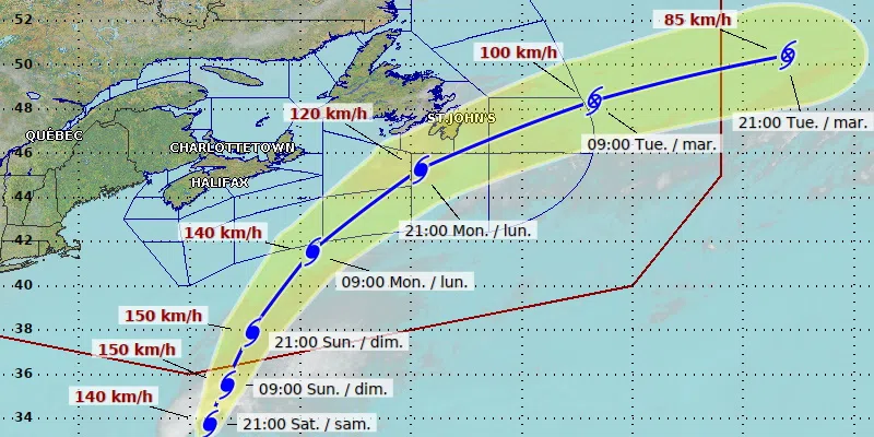
(Latest track as of 9:30 a.m. NL time)
Environment Canada says Ernesto will transition into a post-tropical storm as it passes south of the Avalon Peninsula Monday evening.
But it may still pass close enough to bring some rain and wind to eastern portions of the island from the Burin to Avalon peninsulas, and to a lesser extent the Bonavista Peninsula.
That’s expected to bring large waves and some coastal flooding for the southern Avalon and Placentia Bay.
Meanwhile, although severe fallout isn’t expected on land, advisories have been issued for offshore activity and installations such as Hibernia.
The province’s public safety division also issued an advisory, urging residents to keep an eye on updated forecasts, and take steps to prepare for power outages and flooding.