Wind will be the biggest concern as Hurricane Larry bears down on the Avalon Peninsula.
Environment Canada has issued a full Hurricane Warning for St. John’s and vicinity in anticipation of Larry’s arrival.
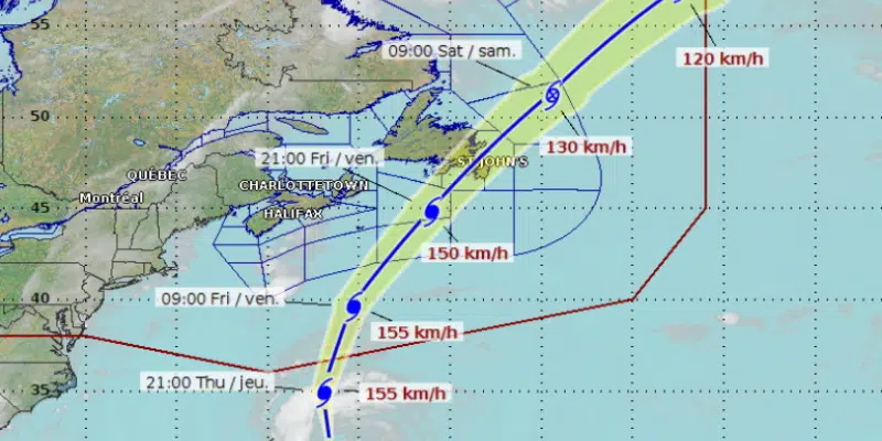
The storm, travelling at a speed of 30 km/h is expected to continue on its current track, crossing the Avalon Peninsula through St. Mary’s Bay through the overnight hours Friday evening and early Saturday morning.
Warning Preparedness Meteorologist Bob Robichaud with the Canadian Hurricane Centre says the fast-moving storm is not expected to have much of an impact in terms of rainfall.
He says the storm will move quickly, so any heavy rain that falls will be short-lived. He doesn’t expect much in the way of road washouts like those seen in previous storms.
The storm is currently packing winds of 150 km/h and is not expected to weaken much by the time it hits the island.
He says the storm will maintain sustained winds of about 120 to 130 km/h as it passes through, meaning that people can expect to see trees topple, and broken branches leading to possible damage and power outages.
The storm is expected to pass through the northeast Avalon area between midnight and 4:00 a.m. Saturday morning.
Robichaud says residents should take precautions and remove or secure anything that might come loose and become a hazard.
Tropical Storm watches are in effect from the Burin Peninsula east to St. Shotts, and from Cape St. Francis northwest to the Bonavista Peninsula. Hurricane watches are in effect from Cape Race north to Cape St. Francis.
The Department of Transportation and Works is working to ensure it’s as prepared as possible should the remnants of Hurricane Larry cause flooding or wind damage on the island.
Minister Elvis Loveless says while they’re hoping for the best, crews are busy checking infrastructure. He says they’re monitoring ditches and bridges, which is part of a normal process throughout the year.
The Canadian Red Cross is also on the ready in anticipation of Hurricane Larry making landfall on the Avalon Peninsula.
Director for the Canadian Red Cross in Newfoundland and Labrador, Rhonda Kenney says not only do governments and municipalities need to be prepared, but individuals must ensure they’re ready for the effects of high winds and heavy rain.
She says it’s important that families have an emergency kit ready and available for a two-to-three day period.

The town of Placentia is keeping a close eye on Hurricane Larry and the storms progress north.
Placentia has seen some devastating floods and water damage from past tropical storms.
Mayor Bernie Power says they’re on the ready and are getting regular updates as the storm approaches. He says they’ve been in regular contact with Environment and Climate Change Canada to help guide them in what needs to be done.

Marine Atlantic is anticipating a disruption in service due to sea swells caused by Hurricane Larry.
Sea swells along the south coast are expected ahead of the storm, which is something Darrel Mercer says Marine Atlantic is watching very closely.
He says at this time they do see some potential for an impact to ferry service on the Port aux Basques run. Marine Atlantic will be sending out advisories for customers once they get a better idea about what the impact may be.
There are no crossings scheduled on the Argentia run this weekend.

(Photo via ExxonMobil.)
Management with the Hebron and Hibernia platforms are keeping a close eye on Hurricane Larry’s forecast track over the coming days.
Officials with ExxonMobil Canada and Hibernia Management and Development Company say based on current forecasts, they don’t expect production operations on either platform to be affected—but say they are continuing to monitor the forecast to ensure the safety of all personnel and their facilities.
The City of Mount Pearl is also advising residents to prepare for the storm, while the City of St. John’s while speak with media Friday morning at 11am to discuss their plans to deal with Hurricane Larry.