The statistical peak of the Atlantic hurricane season passed last week, but because things have been relatively quiet in the northwest Atlantic to-date, doesn’t mean they’ll stay that way.
By mid-September there have been six named storms and one hurricane in the Atlantic, down slightly from the average of 8 named storms and three hurricanes by peak season.
Today marks the statistical peak of hurricane season. Although it’s been relatively quiet so far, it’s likely we’ll see a more active second half of the season as was the case last year. Stay prepared! pic.twitter.com/AmKXjtKOPR
— ECCC Canadian Hurricane Centre (@ECCC_CHC) September 10, 2025
Environment Canada meterorologist Ian Hubbard says they’re currently keeping an eye on a system of unsettled weather off the coast of Africa that could have the ingredients necessary to develop into a named storm.
“Right now it’s just a large area of disorganized showers and thunderstorms, but over the next couple of days it’s going to move into an area that’s going to help it develop and give it a better chance of forming a little bit of organization and possibly turn into a tropical depression later this week. Then we’ll have to follow it and see if it strengthens enough to become a tropical storm, and become the next letter of the season.”
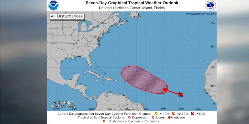
8am EDT 9/14: A tropical wave currently over the eastern Atlantic has a 70% chance of developing into a tropical depression over the next 7 days as it heads west-northwestward across the tropical Atlantic.
See https://t.co/tW4KeGe9uJ for more details. pic.twitter.com/Vqml8plw4k
— National Hurricane Center (@NHC_Atlantic) September 14, 2025