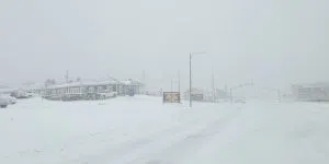
It’s going to be yet another messy weekend on parts of the island. Weather warnings are out for the stretch from St. John’s to Gander as well as the southern and southwestern strip from the Burin Peninsula to Port aux Basques.
Snow begins first tomorrow in the southwest, then spreads to the Burin Peninsula before reaching the east coast and Avalon Peninsula by afternoon. That amounts to a messy drive home.
The St. John’s, Gander, Marystown loop is in for 15-30 cm with high winds—70-80 km/h for most but 100 km/h in the south and southwest and even higher in the Wreckhouse for the first half of tomorrow.
Meteorologist Wanda Batten of the Gander Weather Office says it will be Saturday afternoon before things begin to wind down in metro.
She says blowing snow is going to be an issue starting Friday and all through Saturday.