Firefighters are continuing to contend with high temperatures and strong winds as they battle a number of serious fires in the province.
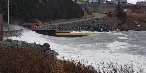
The Kingston fire
The Kingston fire is now estimated at more than 6,500 hectares, having grown overnight along the northern boundary toward Northern Bay.
Ground crews are working the southern edge of the fire and a sprinkler line has been set up near Perry’s Cove.
Officials are fighting the fire by air as conditions allow and a fire break is being cut along the fire’s northern boundary.
The Paddy’s Pond fire
The Paddy’s Pond fire saw minimal growth overnight and is approximately 300 hectares. Fire breaks are being cut along the north, east and west boundaries of the fire.
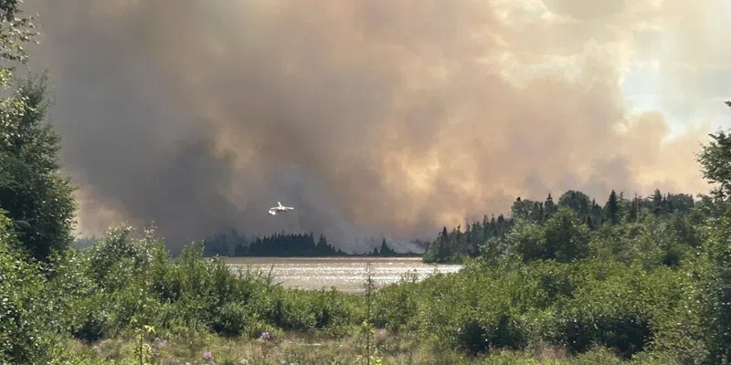
The Martin Lake fire
The Martin Lake fire grew substantially yesterday and overnight – quadrupling in size to about 800 hectares. The fire has not crossed the Bay D’Espoir Highway and remains on the east side of Great Rattling River. No cabins were lost as of this morning.
Regional State of Emergency
A portion of the Bay de Verde Peninsula, from Bristol’s Hope to Whiteway (the communities in the entirety of the Carbonear-Trinity-Bay de Verde electoral district).
- Town of Conception Bay South.
- Town of Paradise.
- The areas known as Southlands and Galway, within the City of St. John’s.
Current Evacuation Orders
These are areas where people have been told to evacuate and cannot return for the time being.
- Town of Small Point–Adam’s Cove–Blackhead–Broad Cove
- Town of Salmon Cove
- Western Bay
- Kingston
- Perry’s Cove
- Ochre Pit Cove
- Burnt Point-Gull Island-Northern Bay
- Paddy’s Pond Industrial Area, including Akita Equipment and surrounding buildings, hangers, Cochrane Pond Family Campground, Country Ribbon Chicken Farm, Sod Farm and the Forestry Depot.
- Portion of the Town of Paradise – ALL properties adjacent to Three Island Pond, including Three Island Pond Road to the intersection of Buckingham Drive, Ellington Close, Angels Road, Hansen Place, Vanellen Place, Dawe Road, Balsamwood Road, Stokes Road and Shalloway Place.
Current Evacuation Alerts
These are areas where people are expected to be packed and ready to go should an evacuation order be called. Bring your belongings with you, you will not be allowed to return if an evacuation order is called.
- Areas known as Southlands and Galway, within the City of St. John’s.
- Town of Paradise: the area on the south side of Topsail Road from the Outer Ring Road exit to CBS boundary, with the exception of ALL properties adjacent to Three Island Pond, including Three Island Pond Road to the intersection of Buckingham Drive, Ellington Close, Angels Road, Hansen Place, Vanellen Place, Dawe Road, Balsamwood Road, Stokes Road and Shalloway Place (this area was placed under an evacuation order earlier today).
- Town of Conception Bay South: starting at Paradise Outer Ring Road turn-off, on to Route 60 through to Manuels River Bridge, up Peacekeeper’s Way to the cloverleaf on the Trans-Canada Highway and back to the Paradise Trans-Canada Highway turnoff.
- Town of Victoria.
Current Evacuation Advisory
-
- Cabin owners in the Martin Lake, Great Rattling Brook and Rushy Pond areas off Route 360 (Bay d’Espoir Highway), including all cabins from Rushy Pond to Rifle Lake (approximately 45 kilometres from the Trans-Canada Highway).
-
Due to increased smoke near Martin Lake, the Bay D’Espoir Highway (Route 360) from the Sunday Pond Resource Road to the Cat Brook turnaround area is closed. The public is asked to stay away from the highway.